
Will Hoyt’s book is the latest title published under the FPR Books imprint. If this excerpt whets your appetite, do order a copy of The Seven Ranges.
Harrison County, OH. Outside snow has started to fall. There are windshield wipers with de-icing fluid on them swishing back and forth as regularly as the radar device on the boat’s roof keeps silently revolving, but here in the wheelhouse it is warm, and the various instrument panels glow like purple, orange, brown, and green embers on a quiet hearth. In addition to a screen showing radar images of approaching tows, there are screens showing how deep the water is at any given moment (lots of silt below dams), the tow’s “swing” relative to its sailing line, and (thanks to real-time GPS) the boat’s actual location on Army Corps of Engineer navigation charts. Captivating though these monitors can be, however, you don’t stare at them all that much. Why should you? Depth finders, swing meters, VHF radio hardware—these are supplementary aids, and, as such, they are off to the side. In this room, the primary focus is the river itself, along with the engine throttles and “sticks” that control the flanking and steering rudders and, thereby, the course of the boat. Where is the river leading, and how do I get there? Those are the questions John in his role as skipper silently asks, and I now make bold to ask them too.
One’s first instinct when attempting to summarize the kind of devastation on view in east central Ohio is to depict the area as archetypically exploited. For example, one can argue that the tri- state area has been “used,” and then (because used once) used again and again in order that the rest of the country, Berkeley citizens included, might prosper or perhaps even satisfy craven needs. There is a disadvantage to this kind of approach, however. Even if “they” (the usual, notoriously vague term for the people charged with exploitation) turn out in the end to include (at least partially) “us,” one is still at all times thinking in terms of good guys v. bad guys, and that fact, in turn, means that one is without access to more structural explanations. Accordingly, I began over time to adopt a different approach, which was to think in terms of an explosion that no one person or group of persons set off or even planned.
If you get hold of the relevant 7.5 minute U.S. Geological Survey topo maps for this area and fit them together on a wall, as I have done, you see some interesting things. Each map, called a “quad” because it shows a fourth of the latitudinal and longitudinal distance that a larger 30 minute map shows, is about 18” wide by 22” high, and if you tack up fifteen of them in correct, contiguous order, you wind up looking at a kind of mural that shows a geographical area measuring roughly 37.5 miles, going from west to east, and 22.5 miles, going from north to south. Given that the distance between Cadiz and Weirton is about 25 miles, the amount of area shown is perfect for getting a read on damaged areas in the entire tri-state area, and thanks to the 20-foot contour intervals employed by the 7.5 series maps, you get the added benefit of seeing all that land in surprisingly sharp, human-scaled topographic detail. Additionally, there is green shading to indicate the presence of woods as opposed to meadows or fields, and, of course, there are also black lines indicating railroads and highways, and blue lines indicating rivers and creeks.
I used to study quadrangle maps for hours when I was planning routes in the mountains, and I was always amazed at the power of these things to hold one’s attention. Is it their reliance on contour, which is in fact (referencing Isaiah here) a level road leading to water? Whatever the appeal, looking at, say, the “Mt. Challenger quadrangle” whetted an appetite for actually walking in high country, and I experienced some of the same pleasures while looking at the Weirton, Steubenville, and Flushing quadrangles once they were all fitted together. For example, I could see that this entire area was in fact, as guidebooks had said, a “dissected plateau”: nearly every ridgetop featured the same elevation. Also, I could spot migration routes: in several places, tributaries emptied their waters into the Ohio River directly across from each other, and, lo—the names of the creeks matched, indicating that the original settlers thought of the creeks as trails. (One set of creeks, the one that the Norfolk and Western railroad follows, is even called “Cross Creek.”) Finally, I could see that the Ohio River, too, “meanders.” You wouldn’t know it, driving north along Rt. 7, but thanks to my trusty wall mural there it was, plain as day: parts of Toronto and all of downtown Weirton used to be river channel.
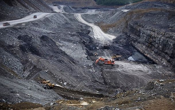
Unlike the topos I was used to studying out west, however, these eastern Ohio topographical maps also showed strip mines, and that particular feature complicated the revelatory potential of the maps. Indeed, when considered singly the maps tended to frustrate viewers more than intrigue them, and for the simple reason that when it comes time to “map” a mined area, draftsmen switch to a rosy, pointillistic pattern to indicate the unavailability of contour lines—which is to say, the loss of the very same reference points that topographical maps depend on to provide the kind of information you buy them for. Given that terrain in a stripped area no longer makes sense, mapmakers in effect throw up their hands and give up when it comes time to chart a surface mine. Consequently, the viewer of an eastern Ohio “topo” often finds himself or herself looking at, well, nothing. But if you put that map on a wall—if you fit the map to other, adjoining puzzle pieces—at that point everything changes. Suddenly the troublesome maps become resplendent with sense, for at that moment you find yourself looking not so much at randomly-occurring, red smudges as at a concentrically organized roseate bloom. Which is to say, you find yourself looking at an explosion. You see this entire region going up in flames.
Just what was it, one wonders, that detonated here? What kind of flames were these? Did they sear minds as well as land? What, in other words, was the extent of the concussive force? And what kind of circuitry could have enabled explosion in the first place?
This book is my attempt to find answers to these questions.
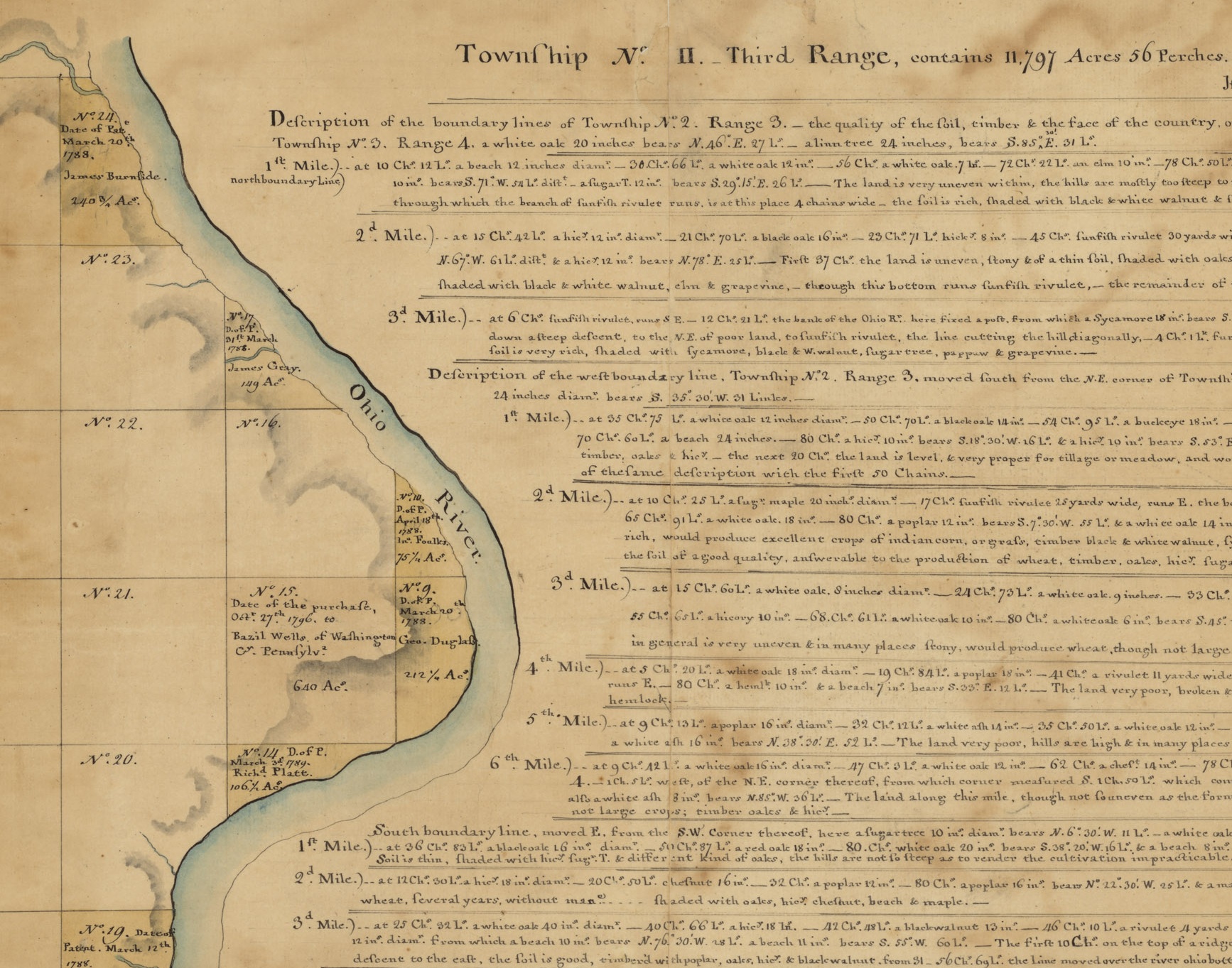
Starting from the assumption that the firestorm, if there was one, had to have resulted from a combination of local or at least localized ingredients, I assembled, over the course of about four years, a list of seven distinct, tri-state specific key events—call them tipping points— that, either singly or together, could have triggered a destructive impact when they made their appearance. Now, in the ensuing chapters, I propose to examine and weigh each of these tipping points in roughly chronological order so that I can then, after cross-checking my findings against the books lined up above my bunk, assess the nature and extent of their combined impact. I plan to start by zeroing in on Thomas Hutchins’ Enlightenment-based 1785-87 land survey of federal lands in eastern Ohio—the so-called “Seven Ranges” whose eastern border the Ocie Clark is now tracing. That survey, which for the first time portioned land according to a grid-like pattern of “section and range” to make it ready for commercial sale, served as the prototype for virtually all national surveys conducted thereafter; indeed, its imprint, as it were, is still plainly in view during transcontinental flights. Next, I plan on turning our attention to revivalism and the second “great awakening,” which, after being seeded by Moravian missionaries who came through eastern Ohio in 1761, broke out in “camp meetings” all over this land—most famously just across the river in Kentucky at Cane Ridge (1801), but originally at Red River, a little further south, under the direction of one James McGready, who was schooled six miles east of Steubenville. And in the fourth chapter I hope to focus on General George Armstrong Custer of 7th Cavalry fame, who (my neighbors take enormous pride in this) grew up on the ridge I look at every morning when I water our animals. I could have picked Steubenville native Edwin McMasters Stanton to illustrate this era in eastern Ohio history. After all, Stanton directed the War Department under Lincoln and is famous for moving 20,000 men across 1,200 miles in less than a week, thereby enabling Ulysses S. Grant to relieve Rosecrans’ forces (after their loss at Chickamauga) and eventually defeat Braxton Bragg’s (Confederate) Army of the Tennessee. For our purposes, however, Custer is the better choice: his career invites us to scrutinize not just the war against the Confederacy but, as well, the wars against Mexico and the subsistence-based traditions on view in the Ogallala and Lakota Sioux.
Not surprisingly, I expect to end that chapter with questions rather than answers; therefore, in chapter 5 I will probably continue to focus on the Civil War era, this time to reflect a little on whether the Civil War could have been focused as much on the substitution of universal suffrage for tradition, as the default means for steering our ship of state, as it was on eliminating chattel slavery.
There is a sudden, loud burst of static as marine VHF channel 13 comes to life. “Sarah Nicole. Just a mile below Weegee Mine. A full tow here. About 6.2 right now. One mile, headed for north-bound tow.” John casts an eye toward the radar screen, sees the approaching barges, and then reaches up with his right hand to pull down a mike with a tightly spiraled cord. “Roger roger, Sara Nicole. Ocie Clark here. We mark you on our screen and will hang until we have you in view.”
The river channel, here, is only 300-feet wide.
Within a few minutes a blue light marking the head of the Sara Nicole tow appears on the far side of a spit at the end of a point, and a couple minutes after that, the boat itself is 50-feet off our port bow, making waves. The pilot on the Sara Nicole pulls once on his whistle chain to confirm port-to-port passing logic, and John answers with a blast from his own. Then the downbound boat is gone.
John turns to me and smiles, a little mischievously. “It’s close, but it’s not like it is in Baton Rouge going around Sugar House Bend.” I nod, remembering that in Louisiana there is ocean-going traffic as well as brown-water traffic, and then, drawn inward by the even sound of Ocie Clark engines and the sight of John smoothly manipulating four rudders to negotiate the same bend the Sara Nicole materialized in, I gradually return to the river road that I see in my mind’s eye.
The commodification of land, the arrival of revivalist energy flow, and the devaluation of tradition—so far I have been talking about bomb parts. In the second half of the book, I plan on widening the focus to include damage. In chapter 6, after noting how eastern Ohio farmland served as a laboratory for the invention and deployment, by Consolidated Coal in collaboration with Bucyrus Erie, of “monster” draglines now in use all over the world by the kind of coal companies that aspire to load two unit-trains per hour, I plan to ask how it is even possible to think of stripping continuously inhabited land on this kind of scale. In chapter 7, after noting that my new hometown was also home to Ohio Congressman John A. Bingham, the man who drafted the due-process and equal-protection clauses of the Fourteenth Amendment, I intend to think about the implications of his decision to frame those clauses in such a way as to make them suitable for use by railroad corporations seeking protection from hostile state governments. And in chapter 8, after asking how those of us who have enabled detonation can continue to claim (as east central Ohioan Americans regularly do) that we are, in the main, bearers of uniquely civilizing light, I consider whether our strenuously consistent maintenance of this claim could itself be a clue to the postulated firestorm’s size and character.
It’s a big undertaking, a journey like this, and it is entirely possible that I will fail in my efforts to describe the damage I see. Nevertheless things could be worse, for in an important sense I did not choose to write a book with these kinds of absurdly rich themes. On the contrary, the twists and turns in the road ahead have come into view slowly and unexpectedly and sometimes even annoyingly, much as evidence does; therefore, if I do fail it won’t be because I tried to imagine too much. Rather, it will be because my mind wasn’t big enough to keep track of this region’s rich history and crack its code. Consequently, I go forth strangely heartened and even hopeful that I might succeed in my attempt to describe and perhaps even explain the hill country presently looming off our port bow.


")


Just got this in the mail yesterday and read the intro and the beginning of the first chapter this morning. A truly fascinating start.
Comments are closed.